
View Map
List of Communities
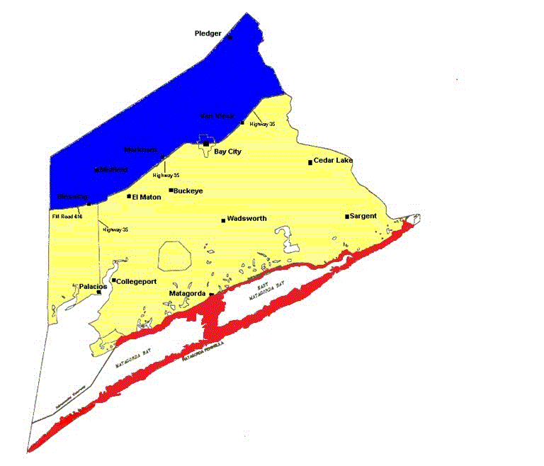
Description of Dividing Line
View a complete list of all Appointed Engineers and the types of inspections that they perform on the windstorm system

This product is for informational purposes and is not prepared for or suitable for legal, engineering, or surveying purposes. It does not represent an on-the-ground survey and represents only the approximate relative location of property boundaries.
The Texas Department of Insurance produces maps for general informational use only. No warranty is made by TDI regarding specific accuracy or completeness. It is the user's responsibility to verify all data represented in the maps.
Notes: All structures located inside the city limits of a city or town which is divided by the dividing line between inland I and inland II shall be subject to the Inland II requirements.
List of Communities
The following is a list of communities located in Matagorda County. The communities have been categorized according to the zone they fall under. If a structure is located in a community or area not shown below, then refer to the county map to determine which zone the structure falls under.
INLAND II- 2006 IBC/IRC with the Texas Revisions, 110 mph 3-second gust design wind speed
| Ashwood | Bay City |
| Blessing | Chalmers |
| Clemville | Markham |
| McCroskey | Midfield |
| Pledger | Rossqu |
| Sugar Valley | Van Vleck |
INLAND I- 2006 IBC/IRC with the Texas Revisions, 120 mph 3-second gust design wind speed
| Allenhurst | Ashby |
| Buckeye | Caney |
| Cedar Lake | Cedar Lane |
| Chinquapin | Citrus Grove |
| Collegeport | Elmaton |
| Gainesmore | Gulf Hill |
| Matagorda | Palacios |
| Rugeley | Rymers |
| Sargent | Simpsonville |
| Wadsworth | |
Written Description of Dividing Line Between Inland I and Inland II Zones:
Matagorda and Brazoria Counties:
Beginning at the Jackson/Matagorda County line intersection with F.M. Road 616 and continuing northeasterly to the intersection of F.M. Road 616 with State Highway 35; continuing northeasterly along State Highway 35 through Matagorda and Brazoria County to the intersection of State Highway 35 with F.M. Road 521; continuing north along F.M. Road 521 to the intersection of F.M. Road 521 with F.M. Road 523; continuing northeasterly along F.M. Road 523 to the intersection with the northwest city limits of the City of Angleton, Texas, and following the western city limits of the City of Angleton to the intersection of the city limits of the City of Angleton with F.M. Road 523; continuing along F.M. 523 to the intersection of F.M. Road 523 with State Highway 35; continuing along State Highway 35 to the intersection of State Highway 35 with State Highway 6, continuing east on State Highway 6 to the Brazoria/Galveston County line.