
View Map
List of Communities
Description of Dividing Line
View a complete list of all Appointed Engineers and the inspections they perform on our windstorm system.

This product is for informational purposes and is not prepared for or suitable for legal, engineering, or surveying purposes. It does not represent an on-the-ground survey and represents only the approximate relative location of property boundaries.
The Texas Department of Insurance produces maps for general informational use only. No warranty is made by TDI regarding specific accuracy or completeness. It is the user's responsibility to verify all data represented in the maps.
Notes:
(a) Except as specified in (b) below, all structures located inside the city limits of a city or town which is divided by the dividing line between inland I and inland II, shall be subject to the Inland II requirements.
(b) Structures located in Brownsville shall be subject to the Inland I requirements regardless of whether the city is separated by the dividing line between inland I and inland II.
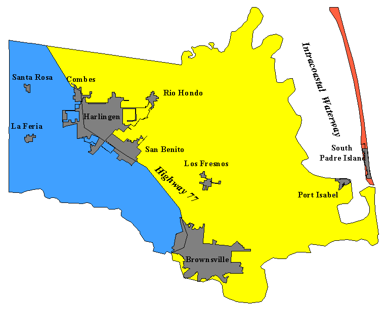
List of Communities
The following is a list of communities located in Cameron County. The communities have been categorized according to the zone they fall under. If a structure is located in a community or area not shown below, then refer to the county map to determine which zone the structure falls under.
INLAND II- 2006 IBC/IRC with the Texas Revisions, 110 mph 3-second gust design wind speed
| Adams Gardens | Palm Valley |
| Bluetown | Primera |
| Carricitos | Ranchito |
| Combes | Rancho Viejo |
| El Calaboz | Rangerville |
| Harlingen | Russelltown |
| La Feria | San Benito |
| Lago | San Pedro |
| Landrum | Santa Maria |
| La Paloma | Santa Rosa |
| Las Rusias | Stuart Place |
| Los Indios | Villa Cavazos |
| Olmito | Villa Nueva |
INLAND I- 2006 IBC/IRC with the Texas Revisions, 120 mph 3-second gust design wind speed
| Abney | Kellers Corner | Monte Grande |
| Arroyo City | Kopernick Shores | Murray |
| Battle of Palmito Hill | Laguna Heights | Palmetal |
| Bayside | Laguna Vista | Port Brownsville |
| Bayview | La Leona | Port Isabel |
| Boca Chica | Lantana | Rio Hondo |
| Brownsville | Laureles | Southmost |
| Buena Vista | La Tina | |
| Fernado | Las Yescas | |
| Holly Beach | Los Fresnos | |
| Indian Lake | Lozano |
SEAWARD- 2006 IBC/IRC with the Texas Revisions, 130 mph 3-second gust design wind speed
South Padre Island
Written Description of Dividing Line Between Inland I and Inland II Zones:
Cameron, Willacy, Kenedy, and Kleberg Counties: Moving south to north in Cameron County beginning at the intersection of the international border of Mexico and the United States following the western city limits of the City of Brownsville, Texas, north to the intersection of the western city limits of the City of Brownsville, Texas, with U.S. Highway 77; continuing along U.S. Highway 77 through the counties of Cameron, Willacy, Kenedy, and Kleberg.