View Map
List of Communities
Description of Dividing Line
View a complete list of all Appointed Engineers and the types of inspections they perform on the windstorm system.


This product is for informational purposes and is not prepared for or suitable for legal, engineering, or surveying purposes. It does not represent an on-the-ground survey and represents only the approximate relative location of property boundaries.
The Texas Department of Insurance produces maps for general informational use only. No warranty is made by TDI regarding specific accuracy or completeness. It is the user's responsibility to verify all data represented in the maps.
List of Communities
The following is a list of the communities located in Harris County that are part of the designated catastrophe area. The communities have been categorized according to the zone they fall under. If a structure is located in a community or area not shown below, then refer to the county map to determine under which zone the structure falls.
INLAND I- 2006 IBC/IRC with the Texas Revisions, 120 mph 3-second gust design wind speed
La Porte
Morgan's Point
Pasadena
Seabrook
Shoreacres
Areas inland of the Intracoastal Waterway and east of the specified boundary line and certain areas in Harris County: To be eligible for windstorm and hail insurance coverage through the Texas Windstorm Insurance Association, structures located in designated catastrophe areas specified in Section 2.1 and Section 2.2 and constructed, repaired, or to which additions are made on and after June 1, 2008 shall comply with the 2006 International Residential Code with Texas Revisions or the 2006 International Building Code with Texas Revisions, for a 120 MPH, 3-second gust wind speed.
2.1 Areas located east of the boundary line specified, except for areas inside the city limits of a city or town divided by the boundary line. The areas located east of the boundary line specified include, but are not limited to, the areas inside the city limits of the cities of Brownsville, Corpus Christi, Portland, Rockport, Aransas Pass, Port Lavaca, Matagorda, Brazoria, Lake Jackson, Angleton, Galveston, Anahuac, Nederland, and Port Arthur.
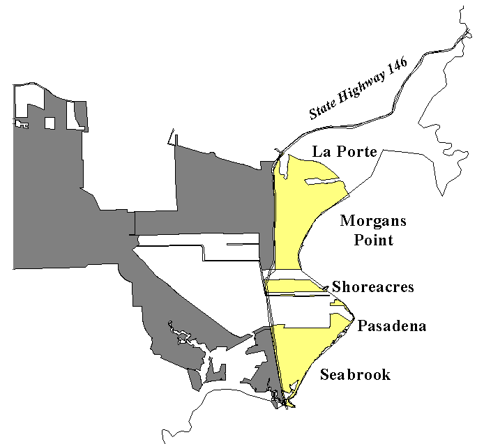
2.2 Areas located east of State Highway 146 and inside the city limits of the cities of Seabrook, La Porte, Shoreacres, Pasadena, and Morgan's Point (all in Harris County). A map that illustrates the areas and cities that are a part of the program for Harris County is presented above.
| January 1, 1988 - Present |
|---|
WPI-8This certificate must be obtained from the Texas Department of Insurance, and is applicable to risks located in the 1st tier counties, in addition to the following cities in Harris County. Location* ConstructedSeabrook After March 1, 1996 Harris County Exceptions:In lieu of a WPI-8, TWIA may request a statement from the local building inspector, an engineer, or an architect for construction between the following dates: Location* ConstructedSeabrook January 1, 1988 to March 1, 1996 * Inside the city limits of these cities and East of Highway 146 |